Maps
Book - 2013 None on shelf No requests on this item
Sign in to request
AADL has no copies of this item
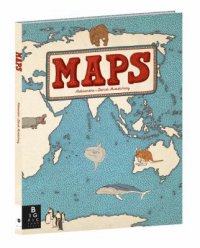
"This collection of 52 highly illustrated maps details not only geographical features and political borders, but also places of interest, iconic personalities, native animals and plants, local peoples, cultural events, and many more fascinating facts associated with each region"--Cover.
REVIEWS & SUMMARIES
School Library Journal ReviewPublishers Weekly Review
Summary / Annotation
Fiction Profile
Author Notes
COMMUNITY REVIEWS
amazing illustrations! submitted by fairytale on June 19, 2014, 9:30am The illustrations in this book are incredible. Very interesting book to look at!
OK submitted by smgop on July 7, 2014, 8:30pm Great illustrations - I think I was expecting more, though...
Maps submitted by SBNB on July 10, 2015, 2:27pm This is a nice book of illustrated maps. It includes various countries from around the world. Great for kids and fun for adults, too.

PUBLISHED
Somerville, Mas. : Big Picture Press, 2013.
Year Published: 2013
Description: 105 p. : col. ill., col. maps ; 38 cm.
Language: English
Format: Book
ISBN/STANDARD NUMBER
9780763668969
0763668966
ADDITIONAL CREDITS
Mizieliński, Daniel.
SUBJECTS
Atlases.
Human geography.